Mile Marker Tour of the Keys

Put the top down, relax and enjoy the ride! You’re on island time now!​

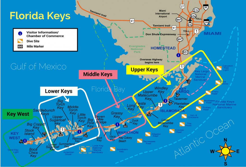
The Florida Keys are comprised of over 1,700 islands, 32 of which are inhabited.

US-1, or the Overseas Highway, is the only road that connects our string of islands to the continental United States. It is approximately 110 miles long and is our Main Street.

You will cross 43 bridges on your way from mainland Florida to Key West. The total population of the Florida Keys is about 85,000, with concentrations in Key Largo, Tavernier, Marathon, Big Pine Key, Summerland Key, Big Coppitt Key and Key West.

Why take the drive?

Experience one of America’s great drives with amazing water views and natural vistas. The Overseas Highway was designated as an All-American Road by the US Department of Transportation. Only 30 other roadways in the nation have earned this prestigious title.

Take your time at a slower pace as you travel south of reality and ease yourself into island time. Lots of great places to eat and drink, as well as quirky tourist stops and unique attractions. Meet the locals to discover the real Florida Keys.

Drive times to Marathon

Figuring rental car pick-up plus drive time…

  • From FLL, about 3 hours
  • From MIA, about 2.5 hours

US-1 is heavily patrolled by both the Monroe County Sheriff’s Department (white cars with green stripes) and the Florida Highway Patrol (black cars with tan roofs). Speed limits bounce between 35, 45 and 55 mph. Stay strictly to the posted speed limit (or within 5 mph if you’re feeling frisky). With little crime to keep them busy, the guys in uniform love to catch the speeders. And, your rental Sebring or Mustang convertible is and easy target. Because US-1 is our Main Street, expect cars to enter and exit frequently. Enjoy the views, but drive safe too.

Directions

From FLL, (Fort Lauderdale Airport), follow the signs to I-595 West and continue on I-595 West (stay in the right lane) to the Florida Turnpike South exit.

From MIA, (Miami Airport), follow the signs to I-836 West. Merge your way over to the left lane and look for the exit to I-836 West about two miles from the airport. I-836 turns into I-874 and then merges with the Florida Turnpike South.

These are all toll roads. Have singles handy (you won’t need many), but this is your best choice. You do not want to go through Miami on I-95. It will take FOREVER.

You will stay on the Florida Turnpike southbound for about 30 to 60 minutes, depending on which airport you came from. It’ll end at Florida City and put you directly on US-1 South. Just follow the signs toward Key West. Everything in the keys is on or just off of US-1.

If you need a bathroom break, now’s the time. There are plenty of fast food joints and convenience stations. You may also want to make a quick stop at Robert is Here in Florida City to pick up some fresh fruit and veggies and have a smoothie.

Once in the Florida City, you have a choice to make. Either one will take you about 30 minutes with no stops. A suggestion is to take Card Sound Road on your trip into the Keys and the 18-Mile Stretch on your way out.

Entering the Keys
  • Take Card Sound Road, which will come up on your left
  •  STOP at Alabama Jack’s for adult refreshments just past the $1.00 toll

    -OR-

  • Stay on US-1 and take the 18-Mile Stretch
  • Travel through the southern tip of the Everglades
Key Largo

Once off Card Sound or the Stretch, welcome to the Florida Keys! You are in Key Largo. 

t’s time to take notice of the Mile Marker signs. Key West, the end of the road, is MM 0. At MM 85.5, you cross the Snake Creek, and this is where it starts to get fun. At the top of the drawbridge, you can see both the Atlantic Ocean and Gulf of Mexico for the very first time.

Below is a Mile Marker by Mile Marker trip guide with some    STOP  recommendations to make your trip pleasurable.


  •  127.5 = Florida City – Junction with Fla. Turnpike and US-1
  • 126.5 = Junction US-1 and CR-905 to/from Card Sound Bridge and Ocean Reef Club, oceanside. Also an alternate route – $1.00 bridge toll, if southbound
  • 126.0 = End/Begin two-lane 18 Mile Stretch
  • 112.5 = MONROE COUNTY LINE – Leave Dade County if southbound
  • 109.3 = Osprey nest, Oceanside
  • 108.0 = Osprey nest, Oceanside
  • 107.2 = Jewfish Creek drawbridge. Exit/enter Key Largo. Begin 18-Mile Stretch
  • 106.6 = Lake Surprise
  • 106.5 = Card Sound Bridge turnoff to/from Ocean Reef via CR 905 oceanside. Also an alternate route, $1.00 bridge toll, northbound to Florida City.
  • If taking CR 905, Mile Markers (MM’s) are labeled “C”. At C-9.25 is a three way stop. Straight goes to the Anglers and Ocean Reef Clubs gated communities. Left goes across the Card Sound toll bridge to Florida City. Now back to MM’s.
  • 105.6 = The location of the railroad depot and the center of the community of Key Largo from about 1910 to 1940. The depot was in the highway median. The community was gulfside.
  • 104.1 = Caribbean Club, gulfside. The set for the 1948 movie Key Largo was modeled for this location
  • 103.5 = The 1920s Key Largo Rock Castle, End of Oceana Drive, oceanside
  • 103.4 = Marvin Adams Waterway Bridge (The Cut), a canal that connects Atlantic to Florida Bay
  • 102.8 = John Pennekamp State Park entrance, oceanside
  • 101.2 = Hibiscus Park, oceanside. This was the center of the 1880s community of Newport.
  • 95 to 100 = This was the early community of Rock Harbor. A small railroad depot was also here.
  • 95.2 = Florida Keys National Marine Sanctuary building
  • 94.8 = Seaside community, oceanside. The 1900s Thompson line packinghouse was in this area.
  • 93.8 = Wild Bird Center, gulfside
  • 91.9 = Old Tavernier Post office, Old Settlers Park, oceanside; Tavernier Hotel, oceanside. This was the center of the early community of Tavernier. Its depot was in the median just south of the post office.
Islamorada
  • 91.0 = Tavernier Creek Bridge; enter Islamorada; Tavernier Creek Marina, Plantation Marina, gulfside
  • 87.0 = Founders Park (Plantation Yacht Harbor), gulfside
  • 85.5 = Snake Creek Draw Bridge; Coast Guard Station, gulfside Enter Windley Key
  • 85.3 = Windley Key State Fossil Reef Geological Site, gulfside
  • 84.3 = This was the center of the community of Quarry that thrived during the construction of the railroad.
  • 84.2 = Theater of the Sea, Holiday Isle Resort, oceanside
  • 84.0 = Whale Harbor Bridge
  • 81.5 = Islamorada Library and park, gulfside; Hurricane Memorial; Cheeca Lodge, oceanside. The library was constructed as a Hurricane Refuge School after the 1935 Hurricane. During construction, the Florida Keys Memorial, known as the Hurricane Monument, was also constructed and dedicated.
  •  STOP – 81.2 = Bass Pro Shops Worldwide Sportsman and Islamorada Fish Company Restaurant, gulfside
  • 81.3 = Green Turtle Inn, oceanside. Part of the structure survived the 1935 Hurricane.
  • 79.8 = Tea Table Relief Bridge. Bud and Mary’s, oceanside. The north approach washed out during Hurricane Donna, 1960.
  • 79.1 = Tea Table Channel Bridge
  • 78.0 = Indian Key Bridge. Lignumvitae Key Botanical Site (State) gulfside in distance. Lignumvitae Key Boat Ramp gulfside; Indian Key Archaeological Site, San Pedro Underwater State Park and Alligator Lighthouse, oceanside at a distance. This area is of historic significance. The islands of Indian Key, Lignumvitae Key and Alligator Lighthouse are prominent artifacts.
  • 77.1 = Lignumvitae Bridge
  •  STOP – 77.0 = Robbie’s Marina, gulfside – FEED THE TARPON
  • 73.6 = Boy Scouts Sea Base, gulfside; Calusa Cove Marina, oceanside. Gulfside was the location of Camp 3 for the WW-1 veterans. Many perished in the 1935 hurricane.
  • 73.4 = Anne’s Beach, oceanside. Gulfside is Veteran’s Island, which is the grown over approach to the veteran’s bridge piers.
  • 73.0 = Offshore on the gulfside can be seen the remains (8) of the concrete bridge piling built by the WW-1 veterans.
  • 72.8 = Apogee of Channel #2 Bridge
  • 71.8 = Craig Key. Rowland Craig built his resort of Craig at the north end of this railroad fill. The drawbridge tender for the Channel 5 railroad bridge lived at the south end.
  • 71.4 = Apogee of Channel #5 Bridge
  • 65.8 = Henry Flagler’s Long Key Fishing Camp occupied the southwest end of Long Key. American author, Zane Grey, vacationed and wrote while at this location in the early 1900s.
  • 64.0 = Middle of Long Key Bridge. If southbound, entering the Middle Keys.

  • 62.2 = Walker’s Island (Little Conch Key)

  • 61.2 = Tom’s Harbor Cut Bridge

Marathon

You are now entering the Islands of Marathon!

  • 61.1 = Entrance to Duck Key; Hawk’s Cay resort, Oceanside
  • 60.6 = Tom’s Harbor Channel Bridge
  • 59.9 = Enter/leave City of Marathon
  • 58.9 = Grassy Key
  •  STOP = Dolphin Research Center, gulfside
  • 56.2 = Curry Hammock State Park
  • 54.6 = Coco Plum
  •  STOP = The Island Tiki Bar and Restaurant, gulfside
  • 53.2 = Our 4 Br/4 Ba Waterfront Home on 121st Street
  • 53.2 = Our 4 Br/2 Ba Waterfront Home on 121st Street
  • 53.1 = Vaca Cut Bridge, entering the business district of Marathon next 8 miles
  • 52.0 = Marathon Airport, gulfside
  • 50.0 = Sombrero Beach Road
  •  STOP = Crane Point Museum of Natural History, gulfside
  •  STOP = Sombrero Beach, oceanside (turn off US-1 onto Sombrero Beach Road)
  •  STOP 48.5 = Turtle Hospital, gulfside
  • 48.0 = US Coast Guard Station, gulfside
  •  STOP = Porky’s BBQ and Captain Pip’s Marina, gulfside
  •  STOP and turn onto 15th Street = Burdine’s Chicki Tiki and Castaway Restaurant, oceanside
  •  STOP and turn onto 11th Street = Lazy Days South Restaurant, oceanside
  •  STOP 47.5 = 7 Mile Marina Charter Boat Row and Salty’s Waterfront Grill, gulfside
  •  STOP 47 = Knight’s Key, Pigeon Key Visitor’s Center and Sunset Grille, oceanside
  • 47.0 = Begin/end of Seven Mile Bridge, Marathon City limits
  • 44.8 = Pigeon Key, gulfside
  • 43.9 = Moser Channel, apogee of Seven-Mile Bridge. Sombrero Light House seen at a distance, oceanside
  • 41.7 = End of original steel truss railroad bridge and begin concrete arch bridge
  • 40.0 = End/begin Seven Mile Bridge
  • Thanks for visiting Marathon! Come back soon
Big Pine
  • 39.5 = Veterans Memorial Park, oceanside
  • 39.5 = Misouri-Little Duck Channel Bridge
  • 39.0 = Ohio-Missouri Channel Bridge
  • 38.8 = Sunshine Key Trailer Park, gulfside
  • 38.7 = Ohio- Bahia Honda Channel Bridge
  •  STOP 36.8 = Bahia Honda State Park entrance, oceanside.
  • 36.0 = Bahia Honda Bridge (4-lanes) old railroad camelback bridge, oceanside
  • 34.0 = West Summerland Key
  • 33.0 = Spanish Harbor Bridge west end
  • 30.2 = Big Pine Key traffic stop light; gulfside to Key Deer Road and Wilder Road
  •  STOP Key Deer Preserve, No Name Pub, No Name Key, gulfside
  • 29.3 = North Pine Channel Bridge
  • 28.1 = Little Torch Key
  • 28.0 = Torch Channel Bridge
  • 27.9 = Middle Torch Key. Entrance to Big Torch Key, turnoff gulfside
  • 27.7 = Torch-Ramrod Channel Bridge
  • 26.6 = South Pine Channel Bridge, east end of bridge, oceanside
  • 27.0 = Ramrod Key
  • 26.0 = Niles Channel Bridge, middle
  • 25.0 – 24.0 = Summerland Key community
  •  STOP 22.5 = Square Grouper Restaurant, oceanside
  • 23.5 = Kemp Channel Bridge, east end of bridge, oceanside
  • 21.0 = Cudjoe Key Subdivision on oceanside. U.S. Navy “Fat Albert” site, gulfside
  • 20.2 = Bow Channel Bridge to Sugarloaf Key
  •  STOP 20.0 = Mangrove Momma’s Restaurant, gulfside
  • 19.3 = Crane Blvd. to gulfside, Sugarloaf School
  • 18.6 = Upper Sugarloaf Key
  • 18.8 = Park Channel Bridge
  • 17.8 = North Harris Channel Bridge
  • 17.6 = Harris Gap Channel Bridge
  • 17.5 = Lower Sugarloaf Key
  • 16.3 = Harris Channel Bridge
  • 15.8 = Lower Sugarloaf Channel Bridge
  • 15.0 = Gate on gulfside to old U.S. Army transmitter site. Now Radio Marti. Bay Point Park.
  • 14.6 = Saddlebunch #2 Bridge, Bay Point Subdivision entrance, oceanside
  • 14.3 = Saddlebunch #3 Bridge, Saddlebunch Shrs./Bluewater Dr., oceanside
  • 13.1 = Saddlebunch #4 Bridge
  • 12.8 = Saddlebunch #5 Bridge
  • 11.4 = Shark Channel Bridge
  • 11.2 = Shark Key
  • 10.0 = Big Coppitt Key
  • 9.7 = Rockland Channel Bridge
  • 9.2 = East Rockland Key
  • 8.0 = NAS Boca Chica Overpass, entrance to NAS, oceanside. Turnoff from both directions US-1.
  • 7.0 = Back gate to NAS, closed, oceanside
  • 6.1 = Boca Chica Bridge, middle
Key West
  • 5.2 = Key Haven, ocean turnoff
  • 5.0 = Stock Island
  • 4.1 = Cow Key Channel Bridge
  • 3.9 = Traffic light. End/begin 4-lane
  • Bear left for Flagler Street, Airport, Martello Towers, Higgs Beach, Casa Marina
  • Bear right for N. Roosevelt, Truman Avenue, Fort Taylor, Historic Seaport, Old Town Key West
  • 2.3 = Salt Run Bridge, N. Roosevelt, Key West
  • 1.7 = Palm Ave; U.S.C.G. Group; NAS Trumbo
  • 1.0 = About South Street
  • Just before Mile Marker 0, you will find the famous Duval Street & places like Margaritaville, Sloppy Joe’s, & the Hard Rock Cafe.
    At the west end of Duval Street, You can find the Sunset Pier (seen in many movies) & Malory Square which comes to life a bit before sunset.
  • 0.0 = MILE MARKER ZERO! Jackson Square County Seat; Key West Post Office